
Introduction
Riverston sits tucked away in the Knuckles Mountain Range, accessible only by rough mountain roads that keep it well off the typical tourist circuit. This high-altitude area offers some of Sri Lanka’s most dramatic mountain scenery without the crowds that gather at more famous viewpoints. The landscape here shifts between grassland plateaus, dense cloud forests, and sheer cliff faces that drop hundreds of meters to valleys below. The relative isolation has preserved both the natural environment and the traditional farming villages that dot the hillsides.
What makes Riverston particularly appealing for adventurous travelers is its authentic mountain character. There are no developed tourist facilities, no paved walkways to viewpoints, and no commercialization softening the raw mountain experience. You come here to camp under stars, wake to mountain mists, and explore terrain that requires some physical effort to access. The reward for this effort is landscapes that few visitors see and a genuine sense of discovery that’s increasingly rare in well-traveled Sri Lanka.
Where is Riverston
Riverston lies in the Matale District of central Sri Lanka, approximately 35 kilometers from the town of Matale itself. The area sits within the Knuckles Conservation Area at elevations ranging from about 1,400 to 1,800 meters above sea level. Getting there requires leaving the main roads and climbing steep mountain tracks that wind through tea estates and small villages before reaching the plateau areas where the main viewpoints and camping spots exist.
The nearest significant town, Matale, provides the typical access point where travelers stock up on supplies before heading into the mountains. From Matale, the route passes through increasingly rural areas, with the road quality deteriorating as you climb higher. The final approaches to Riverston require four-wheel drive vehicles during wet periods when the tracks become muddy and steep sections need the traction that regular cars cannot provide.
Geographically, Riverston forms part of the eastern edge of the Knuckles Range where the mountains drop steeply toward the lowlands of the dry zone. This position at the transition between wet and dry climatic zones creates unique ecological conditions. The eastern faces receive less rainfall than the western slopes, producing different vegetation patterns and more dramatic cloud formations as moisture-laden air from the west hits the mountain barrier.
What Makes Riverston Special
The Mini World’s End viewpoint provides Riverston’s most spectacular feature. The cliff edge drops nearly vertically for 300 meters, creating a precipice that opens views across multiple mountain ridges and valleys stretching into the distance. Unlike the more famous World’s End at Horton Plains, this viewpoint sees relatively few visitors, allowing peaceful contemplation of the dramatic topography without competing for viewing space or dealing with crowds. The name reflects the similar geological formation rather than any official designation.
Cloud forests cover significant portions of the Riverston area, particularly on slopes facing prevailing winds. These forests develop where persistent moisture from clouds and mist supports vegetation adapted to constant dampness. The trees grow gnarled and twisted, their branches covered in moss, ferns, and orchids that thrive in the humid conditions. Walking through cloud forest feels otherworldly as mist swirls through the vegetation, visibility drops to meters, and the sounds become muffled by the dense plant growth.
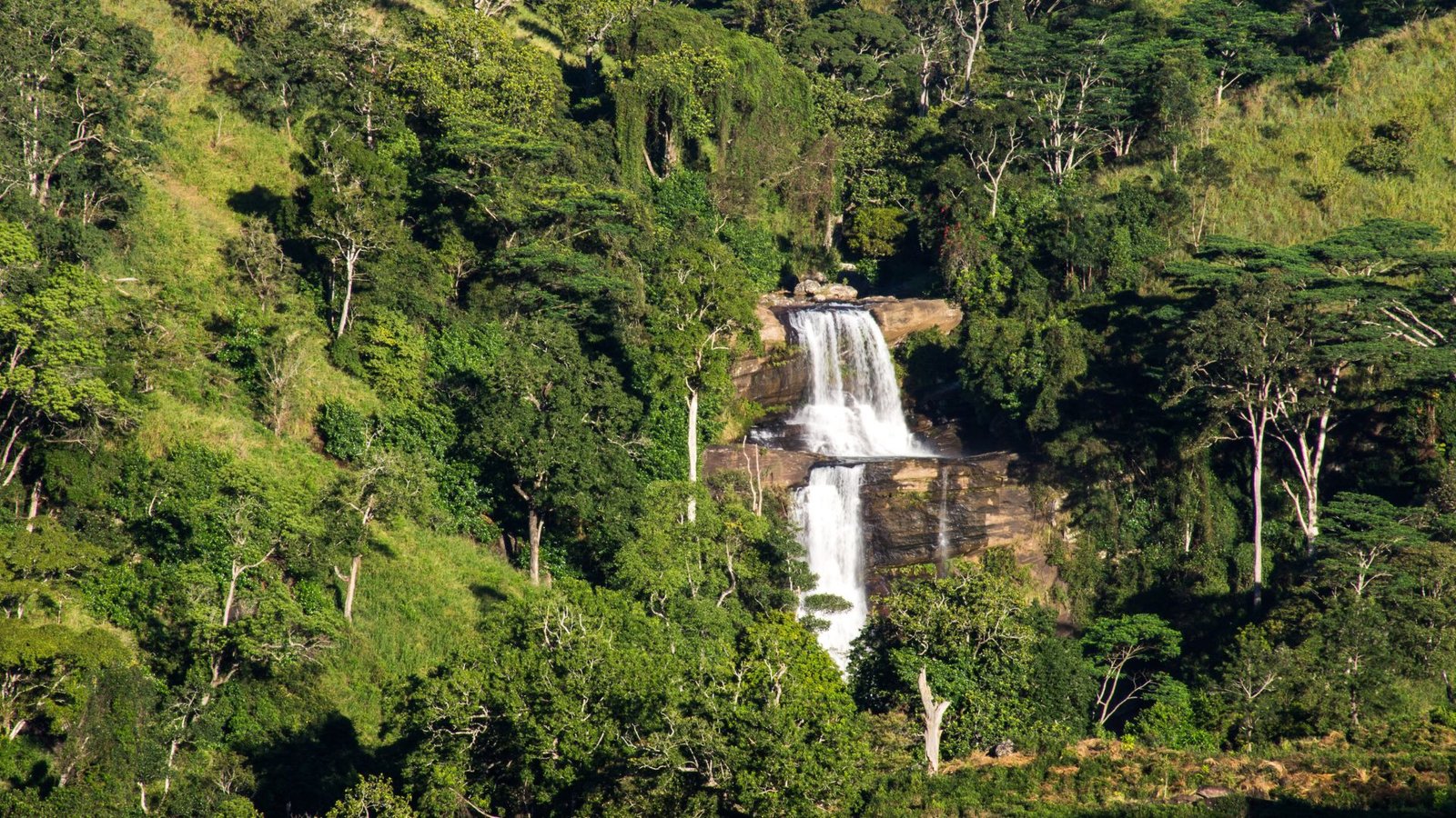
The Sera Ella waterfall cascades down a mountain face in a series of drops that become more or less impressive depending on recent rainfall. During wet periods, the waterfall runs powerfully, sending spray that catches light and creates small rainbows. In drier times, the flow reduces to a gentler cascade, though the setting remains beautiful. The waterfall sits within forest that requires some hiking to access, adding an adventure element to the visit.
Traditional Sinhalese farming villages exist at various elevations around Riverston, their inhabitants practicing agriculture adapted to mountain conditions. Small-scale vegetable cultivation, limited rice farming in terraced fields where water availability allows, and some tea growing on lower slopes provide livelihoods. These communities maintain traditional lifestyles with limited modern conveniences, offering glimpses into rural mountain life that has changed little over decades.
The biodiversity includes species specially adapted to montane conditions. Endemic birds like the Sri Lanka whistling thrush and yellow-eared bulbul inhabit the forests. The vegetation shows high levels of endemism with plants found nowhere else in Sri Lanka or the world. Amphibians particular to these elevation ranges hide in leaf litter and near streams. This concentration of unique species reflects the isolation that mountain environments create, where populations evolve separately from lowland relatives.
Best Time to Visit Riverston
January through April represents the driest period when weather becomes most predictable and road access easiest. During these months, the likelihood of clear morning views from Mini World’s End increases significantly, as mist and clouds typically develop later in the day. Temperatures at Riverston’s elevation remain comfortable even during this period – warm during daytime but cool enough at night to make camping pleasant. The dry conditions also mean better hiking conditions with less mud on trails and clearer stream crossings.
May through September brings the southwest monsoon, though Riverston’s position on the eastern edge of the mountains means it receives less rainfall than western slopes. Rain arrives regularly but often in afternoon or evening rather than all-day downpours. The landscape turns intensely green during this period, waterfalls run at full force, and the cloud forests live up to their name with constant moisture. Camping becomes more challenging but remains possible with proper waterproof equipment.
October and November mark the inter-monsoon transition when weather patterns shift. This period can offer excellent conditions, particularly in November before the northeast monsoon establishes. The landscapes show the effects of previous months’ rain – lush vegetation, flowing streams, and vibrant colors. Morning views often remain clear during this transition period, with afternoon clouds building as the day warms. Tourist numbers stay low, creating peaceful mountain experiences.
December brings some rainfall from the northeast monsoon, though amounts vary year to year. The temperature drops noticeably during December and January, particularly at night when mountain areas can become quite cold. This cooler period actually enhances camping experiences for those with adequate sleeping equipment, as the crisp mountain air and clear night skies create ideal conditions for stargazing and evening campfires.
Morning visits to Mini World’s End work best regardless of season, as clouds typically develop later in the day and obscure views by afternoon. Arriving at the viewpoint by 7 AM or earlier maximizes chances of clear panoramic views before mist rolls in. The early morning light also provides better photography conditions than harsh midday sun. This timing requirement means camping near Riverston or starting extremely early from Matale to reach the viewpoint during optimal conditions.
Things to See in Riverston
The Riverston Peak itself offers 360-degree views from its summit, reached by hiking trails that wind through grasslands and forest patches. The peak stands as the highest point in the immediate area, providing perspectives across the Knuckles Range in one direction and toward the dry zone lowlands in the other. The relatively open summit allows views in all directions without the visual obstruction that forest cover creates at many other mountain viewpoints.
Pitawala Pathana represents an extensive montane grassland area within the broader Riverston region. These grasslands develop at high elevations where conditions prevent forest establishment, creating open landscapes quite different from the typical Sri Lankan vegetation patterns. The grasslands support their own specialized plant and animal communities, and the open terrain allows easier wildlife observation than dense forest environments. The rolling grass-covered hills create scenic landscapes that photographers appreciate.
Ancient rock formations appear throughout the Riverston area, their weathered surfaces showing geological processes operating over millions of years. Some rocks form natural shelters that local farmers historically used for temporary accommodation during agricultural work periods. Others stand as isolated boulders or cliff faces that demonstrate the erosion patterns shaping these mountains. The rock types and formations interest geology enthusiasts while providing dramatic landscape elements for general visitors.
Mountain streams cut through the terrain, their clear water flowing over rocky beds toward eventual confluence with larger rivers in the valleys below. These streams provide important water sources for both wildlife and the farming communities scattered across the mountainsides. During rainy periods, stream flows increase dramatically, and the sound of rushing water becomes a constant background to mountain exploration. The streams also support specialized aquatic life adapted to fast-flowing, oxygen-rich mountain waters.
Small Buddhist temples and shrines appear in villages and along tracks, serving the spiritual needs of mountain communities. These humble structures contrast with the elaborate temples of lowland areas, reflecting the modest resources of mountain populations. However, the settings often prove remarkable – temples positioned to overlook valleys, shrines placed near natural features considered sacred, and meditation spots chosen for their isolation and natural beauty.
Things to Experience in Riverston
Camping at high elevations creates entirely different experiences than lowland camping. The temperature drops significantly after sunset, requiring warm sleeping gear and layers of clothing. Night skies at this elevation and distance from urban light pollution reveal stars with remarkable clarity, the Milky Way visible as a distinct band across the sky. The sounds at night shift to nocturnal species – insects, frogs, and occasionally the calls of night birds. Morning arrives with the sun illuminating valley mists from above, creating ethereal landscapes as fog moves through lower elevations.
Hiking through different vegetation zones shows how elevation and exposure affect plant communities. Starting in grassland, moving through scrub forest, entering mature cloud forest, then emerging again at a viewpoint demonstrates the transitions that occur over relatively short distances in mountain terrain. Each zone supports different birds and other wildlife, making these transition areas particularly interesting for nature observation. The physical challenge of mountain hiking adds satisfaction to reaching destinations.
Photography opportunities abound throughout Riverston, particularly during early morning and late afternoon when light creates dramatic effects. The interplay of mist and mountains produces constantly changing scenes as clouds move through valleys and wrap around peaks. Sunrise from Mini World’s End reveals landscapes in stages as increasing light illuminates successive mountain ridges. The cloud forests present different challenges and opportunities with close-up vegetation details and atmospheric conditions that suit particular photographic approaches.
Village interactions, when approached respectfully, offer insights into mountain farming life. The hospitality of mountain communities often extends to sharing simple meals or hot tea with visitors, creating opportunities for cultural exchange despite language barriers. Observing agricultural work shows adaptation to challenging terrain – terrace construction, water management in areas with limited flat land, and crop selection suited to cooler temperatures and different growing seasons than lowland areas experience.
The sense of solitude and wilderness available at Riverston provides mental refreshment increasingly rare in developed areas. Hours can pass without seeing other people, allowing immersion in natural sounds and rhythms. The absence of mobile phone signals and internet connectivity creates genuine disconnection from digital life. This remoteness appeals particularly to travelers seeking authentic wilderness experiences rather than curated natural attractions with supporting infrastructure.
Why Visit Riverston with a Local Guide
Navigation through rough mountain tracks requires knowledge of which routes remain passable during different weather conditions. The network of roads and tracks can confuse unfamiliar drivers, with some branches leading nowhere useful and others becoming dangerously difficult. Guides familiar with Riverston know which routes work for different vehicles, where particularly challenging sections require extra caution, and alternative paths when primary routes become impassable. This knowledge prevents getting lost or stuck in remote areas where assistance is difficult to obtain.
Identifying safe camping locations requires understanding drainage patterns, exposure to wind, proximity to water sources, and potential hazards like falling branches or rock slides. Experienced guides know established camping areas that minimize environmental impact while providing good conditions for overnight stays. They also understand how weather forecasts translate to actual conditions in these mountains, allowing informed decisions about whether camping is advisable on particular nights.
The ecological knowledge that guides possess transforms nature observation from simply seeing things to understanding relationships. They can identify plant species and explain their adaptations to mountain conditions, recognize bird calls and describe breeding behaviors, point out signs of wildlife presence that untrained eyes miss, and discuss the broader ecosystem functions that make montane environments work. This interpretation enriches the experience beyond visual appreciation.
Timing visits to coincide with optimal viewing conditions requires understanding how local weather patterns develop throughout the day. Guides know that early morning offers best chances for clear views, that mist typically rolls in by mid-morning, that afternoon brings the highest risk of rain during wet seasons, and that certain locations work better in different light conditions. This timing expertise maximizes what you experience during limited visiting time.
Safety considerations in mountain environments include understanding altitude effects on physical performance, recognizing trail hazards like loose rocks or steep drops, knowing what to do if weather deteriorates rapidly, and having communication plans for emergencies in areas without mobile coverage. Guides provide this safety awareness while also carrying first aid supplies and emergency equipment that day visitors might not think to bring.
Access to village communities and private lands requires permissions and relationships that guides maintain. Much of the area around Riverston includes private property or village commons where access needs coordination with local people. Guides handle these arrangements, ensuring visits benefit communities through guide employment and any fees while avoiding conflict over unauthorized access to lands that appear open but actually belong to someone.
The historical and cultural context enriches appreciation of both the landscape and the communities inhabiting it. Guides can explain how traditional agriculture shaped the current vegetation patterns, discuss the challenges mountain communities face maintaining livelihoods, share stories about the area’s role in resistance during colonial periods, and describe the spiritual significance certain landscape features hold for local people. This narrative dimension adds human meaning to the physical geography.